
Local News
The Down Survey Map and the Great Island – Jim Shealy
- Share
- Tweet /home/eastcork/public_html/wdir/wp-content/plugins/mvp-social-buttons/mvp-social-buttons.php on line 68
https://www.cobhedition.com/wdir/wp-content/uploads/2021/04/JS2.jpg&description=The Down Survey Map and the Great Island – Jim Shealy', 'pinterestShare', 'width=750,height=350'); return false;" title="Pin This Post">
Personally I have always had an interest in maps and mapping, pouring over old maps preferably on a wet day is no burden to me, I just love it. Maps, be they old historic maps or today’s computer generated Google Maps are full of information. This information, can tell us a lot about where we came from, population trends, infrastructure, how our towns and cities developed, traditional rights of way, (A very contentious issue at the moment in Cobh) how the land was utilised, journey planning and many other facts about our present world as well as the world of the people who lived in Ireland and other countries before us.
In Ireland, we are fortunate and it is widely recognised that our country is one of the most mapped countries in the world. Most of these historic maps were of course produced for the benefit of gaining information on the inhabitants of the island for the purpose of taxation and raising monies. One collection of maps which I find most intriguing and which are full of incredible information for anyone interested in their history both National and local, are the Down Survey maps of the 17th. Century.
Following the victory of Oliver Cromwell’s Parliamentarian Army over the Royalist Confederate Catholics, who had shown loyalty to the deposed and beheaded King Charles 1, the lands of the defeated Catholic, through acts of parliament were to be confiscated and granted to soldiers of Cromwell’s army, adventurers and mercenaries who had bankrolled the invasion of Ireland.
Ireland in the years 1656 to 1658 was to be surveyed, as the song goes, ‘every mountain, every valley, every tree and bird’s nest’. This survey was carried out under the direction of William Petty Surgeon General of the English army and would be the first ever detailed survey of this kind carried out anywhere in the world.
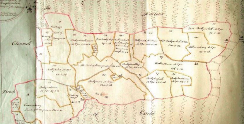
Looking at the local map of the Great Island (Cobh) tells us quite a bit about the island and its inhabitants. The Great Island is and is presently, in the Barony of Imokilly. It is comprised of two parishes, Templerobin to the west and Clonmel to the east. The lands of the island are again divided up by townland boundaries of which there are approximately thirty in total. These townland boundaries go back to the old Gaelic division of land and were devised prior to the Anglo Norman Invasion of the 12th. Century. Many of them to this day carry the old Gaelic names.
In re distributing the confiscated land these townland boundaries were to be used for administrative purposes. Some interesting facts come to light when we look at the names of the disposed and the new owners. Most of those that lost their holdings were Catholic though there are instances of some Catholics who presumably supported Cromwell holding on to their title. Fota Island owned by Francis Smith and the nearby Belvelly area which belonged to the Barry’s or Barrymore family remained unchanged.
The townlands of Ballintra, Ballydulea, Ballymore, Ballywilliam, Ballyleary, and Kilgarvan where the present town centre now stands were all owned by Catholics and were redistributed to Protestant owners, Marino and Cuskinny both in the hands of the Roynane family who also it appears supported the Cromwellian invasion remained unchanged. The Catholics who were disposed included some with old Irish names such as Mc Carthy but were mostly of Anglo Norman descendantcy such as the Roche’s, Walters, Meade’s, Terry’s and Duleay’s. One curious exception to the general rule appears when we look at Ballybrassil, for here it seems the occupying Walters family who were Protestant were evicted to make way for a Catholic David Barry.
The landscape of the island is described in the survey as being of good quality pasture and meadowland. Features on the landscape, some of which still exist include castles, such as Belvelly and Ballymacshaneroe, Walterstown Castle- now demolished, a number of large residences, including a castellated house at Cuskinny, a large house and Dovecoate near present day Cuskinny Court, Dovecoats were used in the late Medieval period to house flocks of doves and pigeons who were an important source of food for their eggs and flesh with the dung from these birds used as fertilizer for the medieval garden.
Two Churches, and graveyards are recorded, one at Ballymore, Templerobin and the other on the Glebe Lands at the Old Church, Clonmel. The island was said to hold over 2500 acres including Spike Island, which interestingly was at the time held in the name of a Dominick Roch and others from Cork.
The name ‘Down Survey’ derived simply from the act of putting the information gathered ‘Down’ on paper ie. recording or writing it.
The maps and further information can be accessed by visiting the webpage of Trinity College Dublin at http://downsurvey.tcd.ie/ Another valuable source of information using maps can be found at http://map.geohive.ie/
This article first appeared in the Cobh Edition on 17th May 2019


John O’Shea extended as Interim Head Coach for June window

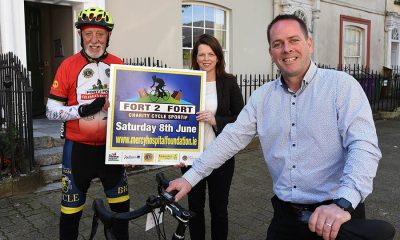
Cyclists of all abilities encouraged to join Fort2Fort Charity Cycle 2024Saturday, 8th June
SIRIUS ARTS CENTRE: COMMISSION: Aikaterini Gegisian

Cobh Youth & Social Projects CLG have the following vacancies

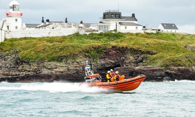
Crosshaven RNLI Assist Two on Disabled Yacht
JOB OPPORTUNITY: Office Admin required, Cobh
JOB OPPORTUNITIES Watersedge Hotel are currently hiring for the following positions

Landmark Partnership: Cruise Ireland and Cruise Britain Join Forces to Boost Cruise Tourism

‘Setting Sail with Ambition’ – Port of Cork Company marks the start of the Annual Cruise Season

OFFICIAL LAUNCH OF SUPERVALU PÁIRC UÍ CHAOIMH AHEAD OF CORK’S FOOTBALL CHAMPIONSHIP OPENER
-
 Announcements3 weeks ago
JOB OPPORTUNITIES Watersedge Hotel are currently hiring for the following positions
-
 Local News3 weeks ago
Spike Island’s After Dark Tours return: Explore the haunting history of iconic prison island once dubbed “Ireland’s Hell”
-
 Events & Entertainment3 weeks ago
Sarah Browne Exhibition at the Sirius Arts Centre
-
 Local News6 days ago
Cyclists of all abilities encouraged to join Fort2Fort Charity Cycle 2024Saturday, 8th June
-
 Local News6 days ago
Crosshaven RNLI Assist Two on Disabled Yacht
-
Announcements6 days ago
Cobh Youth & Social Projects CLG have the following vacancies
-
Events & Entertainment6 days ago
SIRIUS ARTS CENTRE: COMMISSION: Aikaterini Gegisian
-
 Sport5 days ago
John O’Shea extended as Interim Head Coach for June window
-

 Local Soccer2 weeks ago
Cobh Wanderers face College Corinthians in 1st Round of Sports Direct Men’s FAI Cup